![](/images/other/stat-length.png)
![Randonnée Marche Le Saix - R36 - Aujour depuis Clausonne - Photo](https://media.geolcdn.com/t/1900/400/ext.pjpeg?maxdim=2&url=https%3A%2F%2Fservices.sitytrail.com%2FGeolivesWS%2FDownloadMedia.ashx%3FTrailID%3D900901%26Media%3D07eeed14-7ac4-4eb4-8213-2bf0e812ce12.jpg)
R36 - Aujour depuis Clausonne
Camping Les Rives du Lac
Les Hautes Alpes à découvrir ! GUIDE+
![Longueur](/images/other/stat-length.png)
![Altitude max](https://static1.geolcdn.com/siteimages/upload/files/1508320355ic_sort_altitude_max_24dp.png)
![Dénivelé positif](https://static1.geolcdn.com/siteimages/upload/files/1508320355ic_sort_den_pos_24dp.png)
![Km-Effort](/images/other/stat-length.png)
![Altitude min](https://static1.geolcdn.com/siteimages/upload/files/1508320355ic_sort_altitude_min_24dp.png)
![Dénivelé négatif](https://static1.geolcdn.com/siteimages/upload/files/1508320355ic_sort_den_neg_24dp.png)
![Boucle](https://static1.geolcdn.com/siteimages/upload/files/16400158638029165_repeat_loop_refresh_sync_direction_icon.png)
![Marche](https://static1.geolcdn.com/sitytour/trail-icons/101.png)
4h27
Difficulté : Difficile
![Scannez ce code QR pour ouvrir la randonnée dans l'application SityTrail](https://capi.geolives.com/qq0zvz2zws4bq2lad0pu/sitytour/trails/900901/qr.png?size=200)
Application GPS de randonnée GRATUITE
À propos
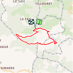
Randonnée Marche de 11,9 km à découvrir à Provence-Alpes-Côte d'Azur, Hautes-Alpes, Le Saix. Cette randonnée est proposée par Camping Les Rives du Lac.
Description
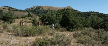
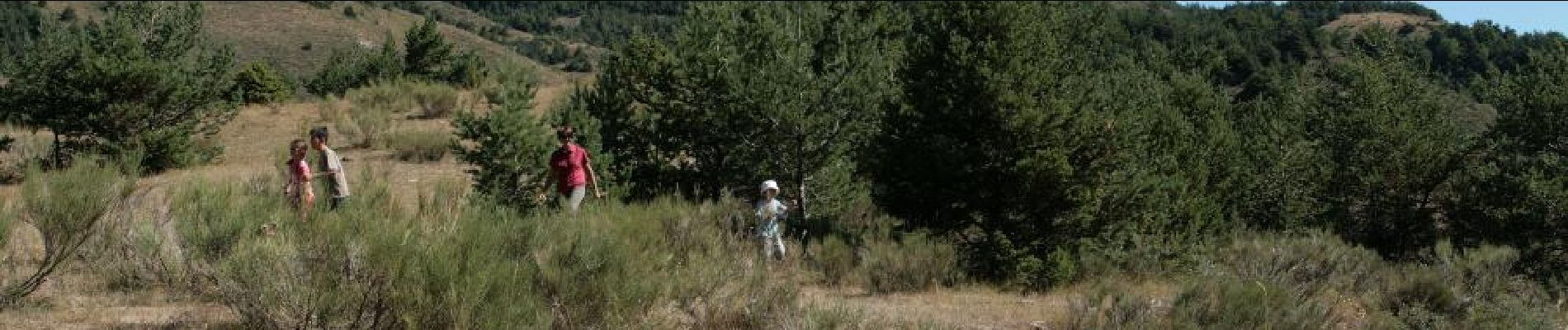
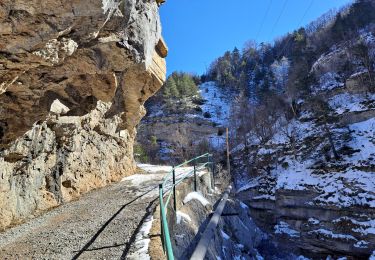
Magnifique randonnée au départ de l’Abbaye de Clausonne (attention, route forestière raide, étroite et avec des à pics, à éviter si vous n’êtes pas à l’aise en voiture sur ce type de route).
Il est possible du partir du village du Saix et marcher sur la route forestière, mais cela ajoute 300m de dénivelé.
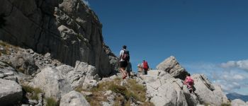
Attention, la partie haute n’est pas évidente à trouver et comporte quelques passages non dangereux (corde pour se tenir) mais délicats.
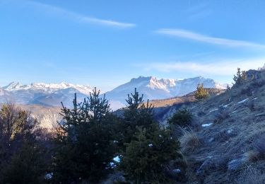
La montée s’effectue sur une route forestière, jusqu’au col de L’Armande. Au col, prendre le petit sentier qui monte tout droit en direction du sud. Le suivre en restant sous les falaises puis suivre la marque qui vous permet de passer de l’autre côté et de continuer jusqu’au sommet. Vue magnifique.
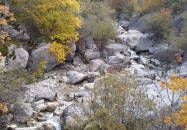
Depuis le sommet, continuer vers le Sud pour commencer la descente. (Passage entre rochers avec ligne de vie). Superbe prairie autour du Lac de Peyssier.
Bref…A faire !
Localisation
Commentaires
Randonnées à proximité
![Randonnée Marche Le Saix - R08 La boucle des cascades jaunes - Photo](https://media.geolcdn.com/t/375/260/f26960bc-bc04-44ac-ad0b-fda399df743b.jpg&format=jpg&maxdim=2)
![Marche Marche](https://static1.geolcdn.com/sitytour/trail-icons/101.png)
Marche
![](/images/other/stat-length.png)
![](https://static1.geolcdn.com/siteimages/upload/files/16400158638029165_repeat_loop_refresh_sync_direction_icon.png)
![Randonnée Marche Le Saix - R07 le fai - Photo](https://media.geolcdn.com/t/375/260/ext.jpg?maxdim=2&url=https%3A%2F%2Fservices.sitytrail.com%2FGeolivesWS%2FDownloadMedia.ashx%3FTrailID%3D890860%26Media%3Dd244d5bc-7fc1-4439-9ce7-046c6af92e70.jpg)
![Marche Marche](https://static1.geolcdn.com/sitytour/trail-icons/101.png)
Marche
![](/images/other/stat-length.png)
![](https://static1.geolcdn.com/siteimages/upload/files/16400158638029165_repeat_loop_refresh_sync_direction_icon.png)
![Randonnée Marche Le Saix - Lac de Peyssier - Photo](https://media.geolcdn.com/t/375/260/8fccd52b-aa7e-4529-9d46-306413d839a3.jpg&format=jpg&maxdim=2)
![Marche Marche](https://static1.geolcdn.com/sitytour/trail-icons/101.png)
Marche
![](/images/other/stat-length.png)
![](https://static1.geolcdn.com/siteimages/upload/files/16400158638029165_repeat_loop_refresh_sync_direction_icon.png)
![Randonnée Marche Le Saix - Montagne d'Aujour - Photo](https://media.geolcdn.com/t/375/260/2e7276b9-57ac-45f4-9854-1a9eec392654.jpg&format=jpg&maxdim=2)
![Marche Marche](https://static1.geolcdn.com/sitytour/trail-icons/101.png)
Marche
![](/images/other/stat-length.png)
![](https://static1.geolcdn.com/siteimages/upload/files/16400158638029165_repeat_loop_refresh_sync_direction_icon.png)
![Randonnée Marche Le Saix - LE SAIX Abbaye de Claussonne n f - Photo](https://media.geolcdn.com/t/375/260/b6678143-8858-4f6e-a21f-ca2b5f31608c.jpg&format=jpg&maxdim=2)
![Marche Marche](https://static1.geolcdn.com/sitytour/trail-icons/101.png)
Marche
![](/images/other/stat-length.png)
![](https://static1.geolcdn.com/siteimages/upload/files/16400158638029165_repeat_loop_refresh_sync_direction_icon.png)
![Randonnée Course à pied Le Saix - Trail 10 - La Traversée d'Aujour - Photo](https://media.geolcdn.com/t/375/260/7960e4b2-4014-4f4e-a3b8-18621ca82d72.jpg&format=jpg&maxdim=2)
![Course à pied Course à pied](https://static1.geolcdn.com/sitytour/trail-icons/103.png)
Course à pied
![](/images/other/stat-length.png)
![](https://static1.geolcdn.com/siteimages/upload/files/16400158638029165_repeat_loop_refresh_sync_direction_icon.png)
![Randonnée Course à pied Saint-Auban-d'Oze - Trail 01 - Le Cirque de Villauret - Photo](https://media.geolcdn.com/t/375/260/11438a15-97de-46a3-a3f1-adac73a9fffe.jpg&format=jpg&maxdim=2)
![Course à pied Course à pied](https://static1.geolcdn.com/sitytour/trail-icons/103.png)
Course à pied
![](/images/other/stat-length.png)
![](https://static1.geolcdn.com/siteimages/upload/files/16400158638029165_repeat_loop_refresh_sync_direction_icon.png)
![Randonnée V.T.T. Le Saix - VTT19 - Le tour d'Aujour - Photo](https://media.geolcdn.com/t/375/260/ext.jpg?maxdim=2&url=https%3A%2F%2Fservices.sitytrail.com%2FGeolivesWS%2FDownloadMedia.ashx%3FTrailID%3D894015%26Media%3D41e434c1-1cd1-4e1f-8ecf-3f42d1205684.jpg)
![V.T.T. V.T.T.](https://static1.geolcdn.com/sitytour/trail-icons/202.png)
V.T.T.
![](/images/other/stat-length.png)
![](https://static1.geolcdn.com/siteimages/upload/files/16400158638029165_repeat_loop_refresh_sync_direction_icon.png)
![Randonnée V.T.T. Le Saix - VTT18 - Col de Peyssier - Photo](https://media.geolcdn.com/t/375/260/ext.jpg?maxdim=2&url=https%3A%2F%2Fservices.sitytrail.com%2FGeolivesWS%2FDownloadMedia.ashx%3FTrailID%3D894014%26Media%3D41e434c1-1cd1-4e1f-8ecf-3f42d1205684.jpg)
![V.T.T. V.T.T.](https://static1.geolcdn.com/sitytour/trail-icons/202.png)
V.T.T.
![](/images/other/stat-length.png)
![](https://static1.geolcdn.com/siteimages/upload/files/16400158638029165_repeat_loop_refresh_sync_direction_icon.png)